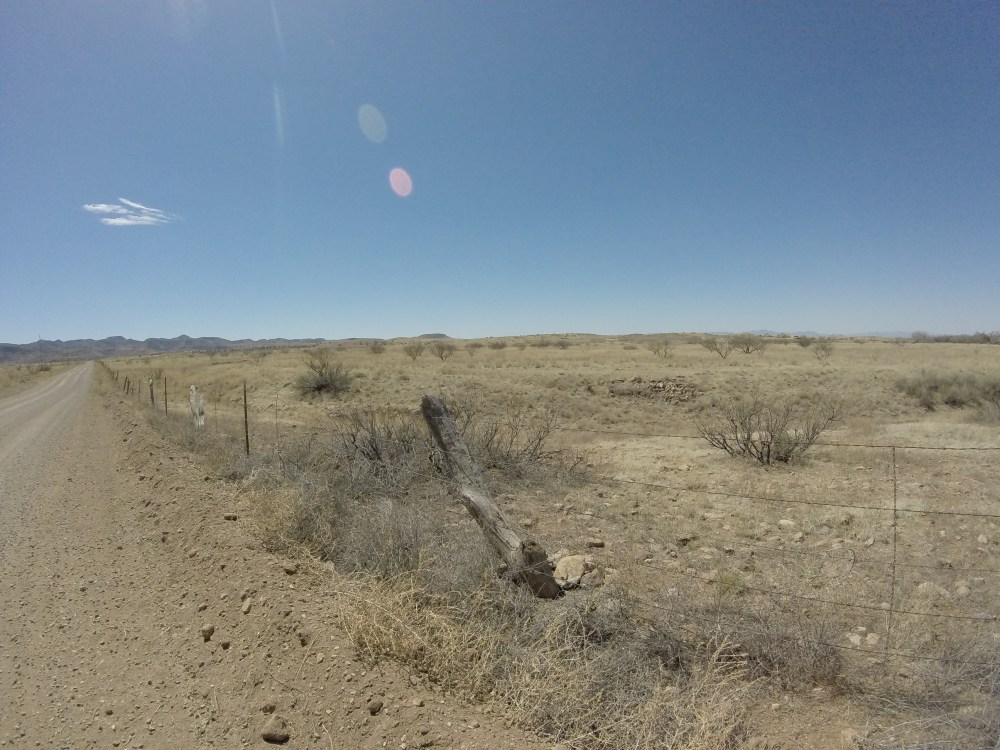
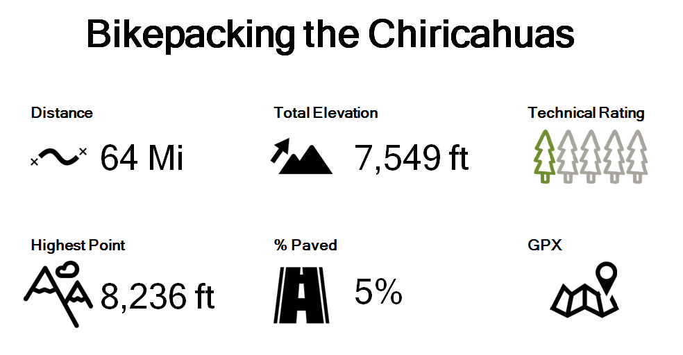
As I squeezed the last few items into my backpack and forcefully tried to cinch the zipper closed I took one last look towards Willcox scanning the vast rolling plains and blowing yellow grass. The grassland stretched on as far as I could see, occasional trees were visible above the grass, like green buoys swaying in a vast yellow ocean. I guess that’s why they call it a sky island. As we began pedaling, the wind brutally pushed us backwards and sideways. It took a lot of strength to steady my loaded down bike. I focused on spinning, circle after circle, even though my legs were already aching from our seven mile hike that morning. We were less than a mile into our 64 mile trek and I wasn’t about to let negative thoughts creep in now. I smiled at Ryan and kept pedaling, but when a group of four cows stopped dead in their tracks and stared us down like we were lunatics on parade I started to wonder if maybe we were a little bit crazy for taking on a weekend trip through the Chiricahua Mountains.
The Chiricahuas aren’t necessarily known for their serenity. The rugged and remote landscape has a unique history of violence and hostility. The mountains were a refuge for Apache Indians during the Apache-American and Mexican conflict in the late 1800s. There are points of interest commemorating great warriors like Cochise and Geronimo. Hiking through the echo canyon area it’s easy to see how the mountains provided protection and safe haven for individuals planning raids against white settlers and cattle ranchers. During our hike into the Heart of Rocks earlier that morning I observed that the rock pillars lining the tall cliffs resembled guards standing erect protecting their sanctuary from intruders.


As we pedaled away from the National Monument on Saturday afternoon the Heart of Rocks seemed like a distant memory. The rock spires were now hidden behind the hillsides protected from the wind that was pummeling us. We pushed forward toward the mountain range looming in front of us, unsure of what lie ahead. Apparently the region is still a safe haven for nefarious activity, according to park rangers, and is used by smugglers and drug traffickers; in addition black bears and mountain lions are common. Luckily, after a few miles we were protected from the wind and washboarded road leveled out providing a smooth surface for the long climb up to Onion saddle. Our plan was to take Forest Road 42 to Pinery Horsefall Trail and Shaw Peak Trail and then rejoin the road at Onion Saddle. From there we would head down into the small town of Portal, a camping and bird watching destination and return back up and over the mountain the next day.
After about 7.5 miles we turned off the road onto the single track, we giddily wove through rocks and branches for about 30 seconds, then we had to dismount to get over a fallen tree, then another and another, and then after a half mile we reached a point where the trail was indecipherable. Unfortunately, the trail damage from the 2011 Horseshoe Fire and the subsequent flooding left it too difficult to navigate. We opted to ride back down to the smooth dirt road and continue the difficult climb up to the saddle. It was interesting to get a small taste of riding single track with a loaded down bike. The large bags make it difficult to get into the attack position especially when you keep hitting the rear seat bag every time you try to shift your weight back.


Back on the road it was less than five miles to the saddle with 1,600 feet of climbing, topping out at 7,600 feet. The climb to the top was tough, we weren’t used to the altitude and our heavy bikes didn’t help (keep in mind we had already climbed 1,000 feet over the past 8 miles). Finally we twisted through the last set of switchbacks and crested Onion Saddle, we were greeted by raging winds. Looking at the recorded weather, the gusts were somewhere north of 30 mph. Normally I would celebrate reaching the summit of a climb with some pictures and a snack, but this time I was eager to start the descent. On the backside of Onion Saddle it was roughly 14 miles downhill to our destination, Sunny Flat campground, near Portal, with one small detour on Herb Martyr Road from some extra miles, sight seeing and climbing.


Though it didn’t seem possible the landscape had drastically changed again. As we cruised down the switchbacks I was marveling at the beautiful red rocks and thick dark green pine forest. I had read that our destination was called the Yosemite of the Southwest so I was very curious to see how it would look. Though the valley and granite monoliths weren’t as drastic as Yosemite, the description was surprisingly fitting. Sunny Flat campground was absolutely beautiful. The campsite was full when we arrived, but we were lucky to snag a site from a family that was leaving that day. As we waited for them to pack up and leave we chatted with the campground host and a retired couple enjoying an extended road trip through the Southwest. Once our site was available we set up camp, relaxed by the creek and enjoyed some celebratory Boulevards, which Ryan graciously carried in his top tube bag all day long (priorities). We were joined by two deer as we ate our alpine air dinners followed by apple crisp for desert, then it was early to bed (seriously, this might be my favorite thing about camping). We had a big day of climbing ahead of us!
The next morning we woke up around 6 AM and got ready for day two. It was freezing so I put on every piece of clothing I brought while Ryan made coffee. I guess neither of us slept well the night before because in his tired state he accidentally boiled fruit punch flavored EFS (sports drink) for his coffee instead of water. Apparently, it tastes as bad as it sounds. After taking a few sips we topped off our water bottles and set out on the Cave Creek nature trail, which conveniently began two feet from our campsite. Ryan quickly sped away on the flowing single track while I fumbled around struggling to shift with numb fingers and constantly pulling my pant leg up so it wouldn’t get stuck in the drive train. After about two miles the Cave Creek nature trail reaches the Silver Peak trailhead. Due to the fact that I am always looking for the opportunity to do more climbing we headed up the mountain. I had read about how beautiful this trail is and wanted to climb up to a neat rock feature known as The Fingers. However, much like the day before the trail was difficult to ride with fully loaded bikes and required more hike a bike than we wanted to tackle before breakfast, and a proper cup of coffee. We quickly descended back down the way we came and took a short stretch of pavement into the town of Portal to have breakfast at the Portal Café & Lodge.


The food and service at the Portal Café & Lodge were great and this would make a great resupply point for anyone on a longer journey. In addition to small town charm and the restaurant they also have a small grocery store. After filling our bellies with pancakes, french toast, eggs and salad (for me) we got ready to ride back to the National Monument. Our return route had us going through the even smaller town of Paradise. It was so small we were on the other side of it before I even realized we had reached it. The only real notable things we saw in Paradise were a clay adobe house and a cemetery in the middle of the National Forest. As we pedaled through Paradise I could see the saddle looming ahead of us, I craned my neck skyward looking up certain that it couldn’t really be where we came from the day before. I sheepishly asked Ryan, “Do we have to go all the way up there?” “Yep.” he replied, I gulped and prepared myself for a long slog up the hill in silence.
The climb back up to Onion Saddle was grueling. There wasn’t much traffic on the way up, one family that appeared to have no idea where they were going (even though the road only went one way) and a couple of birders determined to spot the Mexican Chickadee. Of course Ryan stopped to chat with both groups, while I on the other hand continued on my silent journey up the mountain. After quickly gaining 3,000 feet in less than 15 miles we were at the saddle, only the climb wasn’t over. To change up the scenery we planned to continue upward to Rustler Park and then ride through Barfoot Park and back to FR 42 via FR 357. From everything I read both of these parks provided scenic views of mountainside meadows and wildflowers. Unfortunately, there wasn’t much to see except for more wildfire damage and it was actually kind of depressing.


We ate our lunch at Rustler Park and continued onward, finally going downhill. FR 357 was less maintained than the road we had been riding on and felt more like double track trail than a road. Ryan quickly descended, skirting around rocks, pine cones and shadows while I slowly followed behind him. We were cruising right along and then came to an abrupt stop at orange barricades, the road and our route back vanished right before our eyes. Once again we had to back track, disappointed and exhausted we pushed our bikes back up the road for a while, too tired to pedal through the steep rocky terrain. Note to self don’t use books from the nineties to scout your route when there have been significant forest fires and flooding since then.
Once we were back to rideable portion of the road it was 15 miles downhill back to our car, of which the first six miles were pretty intense. We had to navigate steep, tight switch backs with dramatic drop offs around each corner. I hugged the inside of the road and steadily worked my way down the hill. Descending this side was a bit scarier than the day before, as the drop offs were more exposed. I tried to remember everything I have been learning about bike handling and reassured myself that the road was plenty wide, so if I did somehow have a freak accident and fall I would just fall over in the middle of the road and not go tumbling down the mountain. I was really happy to comfortably navigate the switch backs without a death grip on the handle bars and without feeling the urge to vomit, stop or walk. This was a huge accomplishment for me! After about six miles it was smooth sailing back to car. And finally for the first time in two days we could easily spin at a high cadence and start flushing all of the lactic acid out of our legs.


As we got closer to the picnic area all of our fears about bears, mountains lions and the unknown were behind us. We now started worrying about if our car was still in the parking lot, overnight parking is typically not permitted at the National Monument (luckily we got permission from a park ranger). We stopped at the monument entrance for one last picture and quickly pedaled up the road, relieved to see our Element still in the parking lot, safe and sound. We celebrated with some cokes that were still ice cold in our trusty Coleman cooler, that thing is legit, changed out of our kits and headed back to Phoenix, another epic weekend in the books!
Things to know about this route:
- There are several camping options along the route – most are first come first served and there are dispersed camping areas as well
- Water is available at the campsites during the spring and summer; several creek crossings provide opportunity for water if needed
- No overnight parking is allowed at the Chiricahua National Monument Visitor Center
- There are several options for single track riding along the route; but prepared for hike a bike or backtracking due to the fire and flood damage
- The Portal Café & Lodge has a grocery store and restaurant and is open daily from 7:30 – 7:00

This is my favorite area of the world.
LikeLiked by 1 person
I literally just told Ryan that I forgot to mention in the post that we went based on your recommendation! Thanks so much we were thinking the whole time if we had not started the blog we wouldn’t have been there. We loved it and hope to make it back soon! Thanks again!
LikeLike
Wow! What an adventure. Sounds a bit scary but glad it was fun for you two!
LikeLiked by 1 person
To me, the Chiricahuas’s most amazing time is the summer. But (big but) you can’t be afraid of thunder and lightening or afraid of getting wet…or wonder if the tent is going to turn into a bowling ball
Most every summer afternoon, sometime around 2 or 3pm, spectacular storms show up and drench the place. And when the storms quit, it is so quiet you can hear your heartbeat in your ears.
In the early 1980s (before the fires) there were a few places 4 or 5 miles west of Rustler Park where, during the rainy season, the water pooled up into several 4 to 6 foot deep and 15 to 20 foot wide pools. One pool had a nice ledge where one could sit in the sun and dry off. For whatever reason it seemed to be a most “unpopular” place as we never saw anyone else there. Maybe it was the long drive on the dirt road and the difficult to follow trail. 🙂
I went back there a few years ago (after the 1994 and 2011 fires) with my wife and daughter. The peace and quiet was the same, but the runoff had filled in the pools so that they were mere puddles. It was also in that awkward time between the trees being gone and the meadows not yet having formed so, while it was interesting to see how nature was taking advantage of the change, it was still kind of depressing.
When life isn’t so busy, I’ll be back there looking for more pools. 🙂
And, maybe, most of the burned trees will have fallen over by then and I won’t need to be constantly looking for hazardous not yet fallen trees.
LikeLiked by 2 people