Every year between Christmas and New Year’s Ryan and I like to plan a little getaway. In the past we have been to Joshua Tree, Channel Islands and Saguaro National Parks; however this year we stayed local and planned a short overnight bikepacking trip to the Sheep Bridge on the Verde River. Before we left, I discovered that the Sheep Bridge is part of the Register of National Historic places so I wanted to learn more about it. I did a little research and found out the bridge was built by the Flagstaff Sheep Company and Howard Sheep Company in 1943-44 with materials from Arizona mines. The original sheep bridge was destroyed in 1988, but the forest service reconstructed it in 1989. I also learned a little bit about the sheep herding industry in the United States and Arizona. While it is not very popular today, sheep herding reached its peak in the 1940s with over 56 million sheep in the United States. Back in those days there were eight outfitters in Arizona that herded roughly 24,000 sheep from the valley up to White Mountains each spring and back down to the Valley each winter. The trip was 220 miles and the sheep would travel roughly 6 miles per day. Nowadays there are only 5 million sheep left in the United States and long gone are the annual trips to move herds from the valley to the high country. From what I can tell the last trip was in 2011 made by the Sheep Creek Sheep Company from Chandler.
All of my research on sheep herding, had me impressed and intrigued with the bridge, but the Verde River is pretty amazing in its own right. The river begins at Sullivan Lake near Paulden, Arizona and flows 170 miles to the Salt River near Fountain Hills. The 40.5 miles between Beasley Flat and Horseshoe Dam are designated as a Wild & Scenic River. The first time we heard about wild & scenic rivers was when we rafted the Flathead River in Glacier National Park, so we were excited to learn that a river so close to home was also among this distinct classification. Rivers in the National Wild and Scenic Rivers System capture the essence of all waterways that surge, ramble, gush, wander and weave through our country…the National System protects 12,598 miles of 203 rivers in 39 states and the Commonwealth of Puerto Rico; this is a little more than one-quarter of one percent of the nation’s rivers. – www.rivers.gov
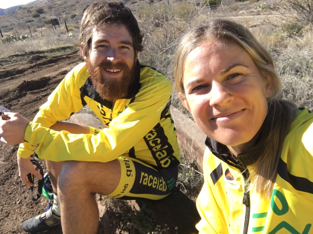
As we prepared for this bikepacking trip I tried to make the most of some of the things we learned on our last, unsuccessful, trip. For starters, we were more flexible with our dates this time around and paid better attention to the weather forecast. We planned our trip around the forecast, instead of in spite of it. Secondly, we drastically simplified our food strategy and packed a lot less of it. Last time we probably had close to 10 pounds of food, which is ridiculous and we hardly made a dent in it. And finally, I decided to bring less ‘luxury’ items. On the last trip I packed extra clothes, a brush, a bowl and a journal. While these items didn’t weigh much, I didn’t need them so hauling them around all day long was pretty silly. At the end of the day we both still hauled around 60 pounds, shaving off one or two pounds each.
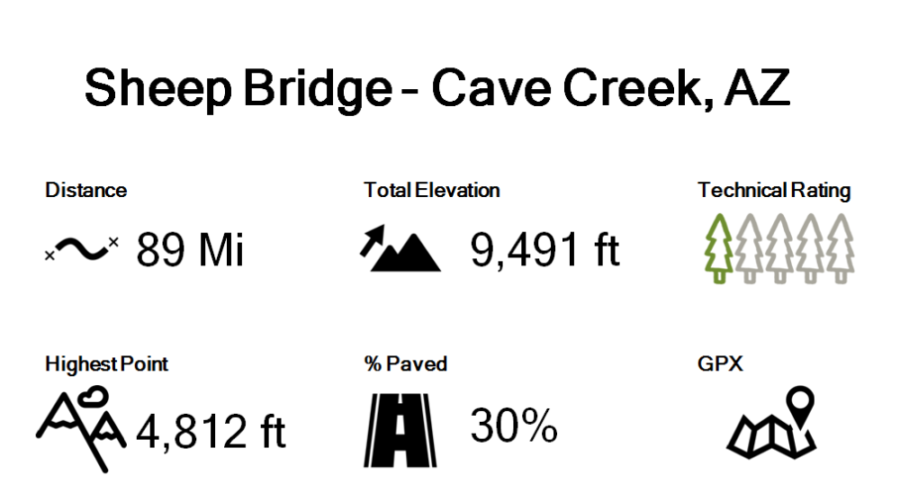
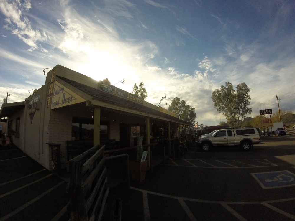
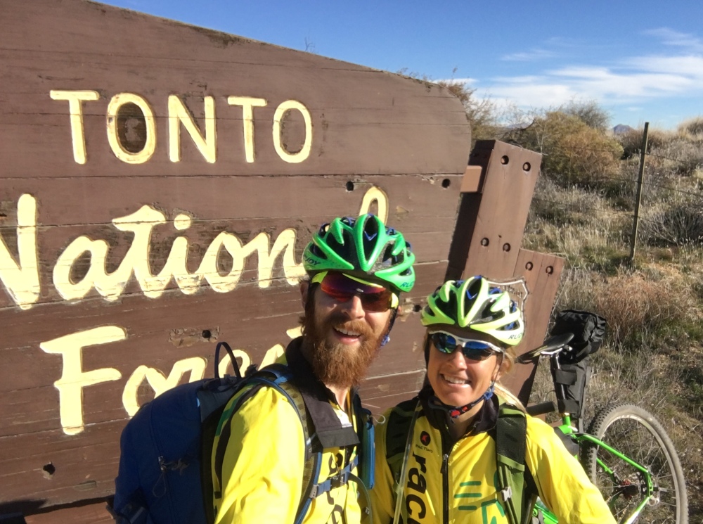
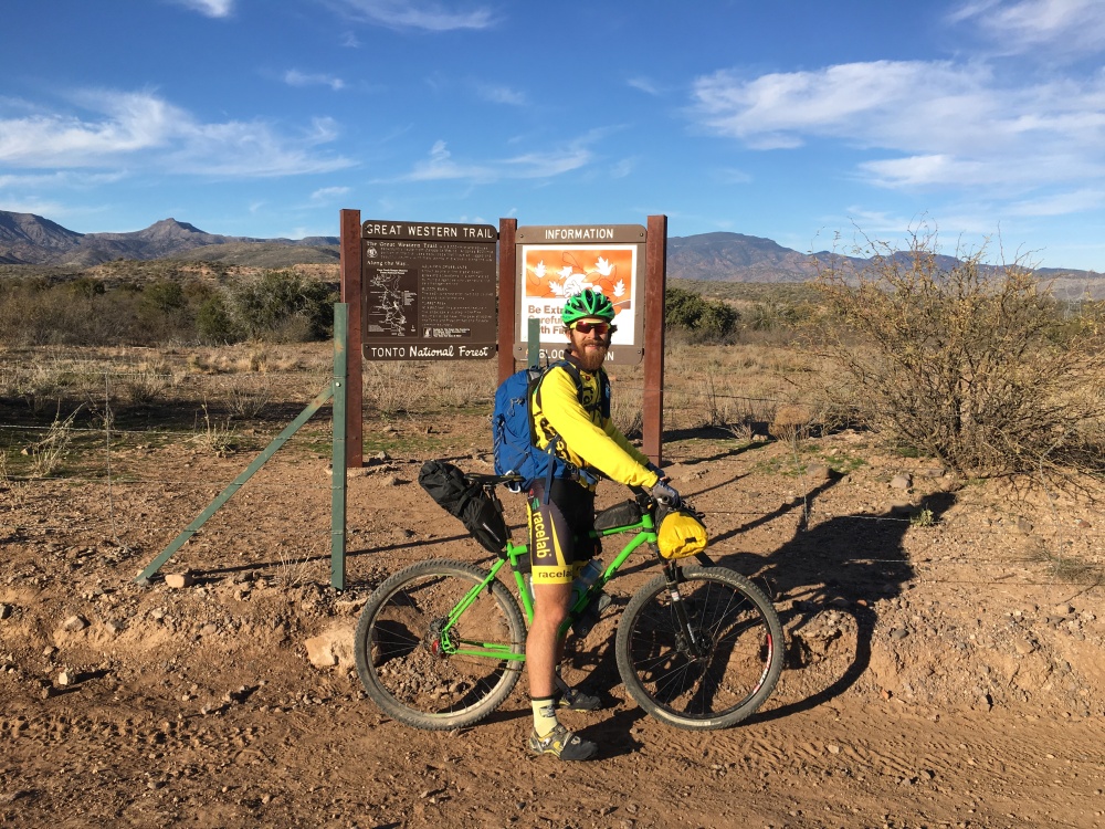
This loop route to the Sheep Bridge travels through the beautiful Tonto National Forest on well maintained dirt and gravel roads and includes some paved sections to and from the nearby town of Cave Creek. We started our ride at the World Famous Flat Tire Bike Shop & Local Jonny’s Café. This was a great starting place for a warm, satisfying breakfast and any last minute bike needs. From Local Jonny’s the route takes Cave Creek Road East/Northeast through Cave Creek, Carefree and North Scottsdale to the Tonto National Forest. While the road is paved, the charm of the towns and views of the surrounding desert and mountains are incredible, this is one of our favorite spots to train on our road bikes. The gradual climb out to Tonto National Forest is long; the road climbs for roughly 9 miles and rises 1,200 feet, without any break. The hill flattens out just past the Bartlett Lake turn off, which is the return point of this loop. After the first climb is completed, it’s roughly 5 miles of winding, rolling hills past the Sears Kay Ruins to the end of the pavement.
Once on the dirt it’s roughly 15 miles of rolling terrain, climbing another 1,350 feet up to the highest point. For the most part the road is well graded and smooth dirt with some washboards here and there. The road passes several camping and recreation areas, Seven Spring Campground, Bronco Trailhead, Cave Creek Trailhead and Cave Creek Campground. While fairly primitive, any of these would make a great place to camp for the first night if splitting this trip into three days. While it may seem like a short first day, this ride has a lot of climbing, which can take its toll on you when you are hauling gear. Splitting the trip into three days would also allow one to spend more time exploring and relaxing at the Sheep Bridge. Between the Bronco trailhead and the Cave Creek trailhead the road passes by the intersection of E State Highway 562 which climbs to the top of Humboldt Mountain; this is our favorite climb, it’s a challenging 3.8 mile climb of 1,631 feet that peaks just shy of 5,200 feet with amazing views. The mountain is easy to spot because it has a white radar dome on the top that looks like a golf ball; in fact the dome was visible for almost our entire trip. I felt like it was taunting me, even hours after passing it, I felt no further away from it!

The climb to the halfway point gets fairly tough at the end, with two miles at 7% grade. At this point, my quads were starting to cramp so I had to take breaks and walk small sections to stretch out my legs and recruit different muscle groups. There was also a fair amount of traffic from off road vehicles, trucks and dirt bikes which can be slightly intimidating when you are moving so slow. Once we reached the top the descent finally began; from here it was 10 miles of flat and downhill riding to Bloody Basin Road. The road does get rockier on this side of the mountains, but it is definitely rideable and less traveled by cars. There was one small stretch of switchbacks bench cut into the side of the mountain that put a demon in my head and caused me to walk again (I’m afraid of heights), but for any other rider this would be a nice time to make up some ground and cruise at higher speeds. After the switchbacks you pass several cattle guards and we rode through several groups of free range cattle enjoying the warm sunshine and grazing alongside the road. We even saw some wild horses, which is always an incredible sight.
Finally we made it to Bloody Basin Road, and had 12 miles to go to reach the Verde River. Unfortunately, Bloody Basin Road is significantly rougher than Forest Road 24. Up until this point the route is definitely doable on a cross bike or gravel bike. However, this section has large rocks, off camber sections and better suited for a mountain bike. It is all rideable for the experienced mountain biker, but for riders more comfortable on dirt roads this section may be challenging and require some walking. It is also a common belief (or at least it was ours), that it’s all downhill to the river. This is mostly true, but at mile 42 a nice, rocky 1.6 mile climb at 6% grade awaits.
That last climb was definitely the low point of our ride. After a day of making bad nutrition choices (choosing not to eat or drink anything after lunch) I was exhausted and cramping. Pushing a bike and gear that weighed half my body weight had gotten the best of me. I knew we were running out of time to get to the river before sunset but I did not have the strength or mental energy to find rideable lines and pedal. We were pushing our bikes up the rocky hill while the sun was beginning to set and still had 4 miles to go to the river. At one point a lady drove past us in her OHV heading out from the river and stopped to inform us that the road conditions were only going to get worse, a lot worse. She then proceeded to tell us “fair warning” and drove off shaking her head. While, I think she was trying to be nice, I really have no idea what she thought we were going to do, it was 4 miles to the river and almost 50 miles back to civilization. Luckily, she was wrong and after we got up the hill we were able to ride part of the way down. We had to start walking again with about a mile to go because of steep switchbacks down to the river filled with rocks. While rideable, it was now dark and we only had one headlamp between the two of us so we were forced to walk.
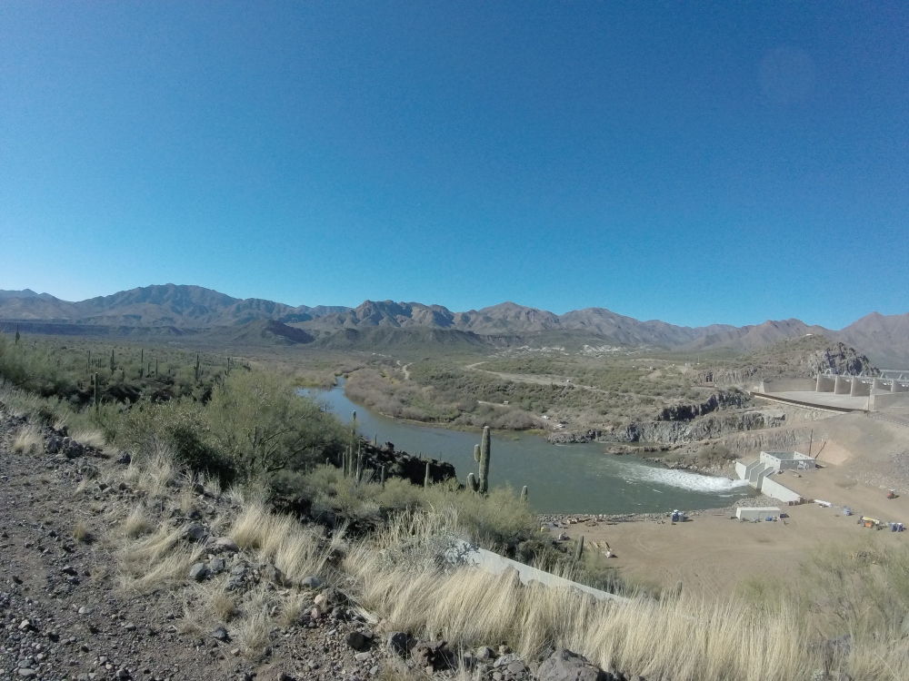
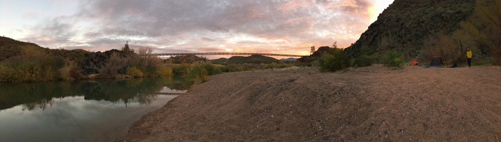
Finally by the light of our headlamp we could see the river, we could hardly see the Sheep Bridge until it was right in front of us. At first we were tempted to set up camp right beside it on the northwest side of the river, but then we could see a small campfire underneath the bridge on the other side. So we crossed the bridge in the dark and gracelessly stumbled down through rocks to the riverbank. Hoping we didn’t tick off our fellow campers too bad by making such a grand entrance we found a nice flat area by the water and (Ryan) started setting up camp in the dark. There are several places to camp on the beach but there are no established sites or amenities. After making and eating our dinner and filtering some water we headed to bed. It was very cold and windy so we were eager to get into our sleeping bags, since we did not pack much cold weather gear. The starry sky was brilliant and I was quickly lulled to sleep by the breeze rushing through the canyons over the river.
The next morning we woke up early, cleaned up camp, ate our breakfast and went to check out the Sheep Bridge in the daylight. We also chatted with the other campers, who turned out to be really friendly and cool! Sadly we did not have time to check out the hot springs. Next time we go, taking a dip in the hot springs and jumping off the rope swing into the river will be top priority! After filtering some more water from the river we were off (the water was perfectly clear and tasted amazing!).


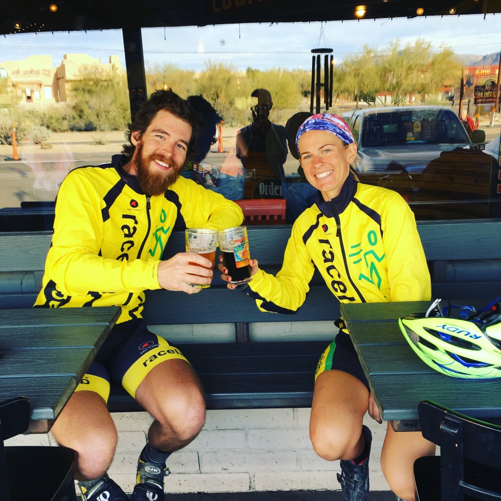
For our return route we headed south from the river towards Horseshoe Dam. This portion of the ride was much easier than Bloody Basin. The road was smooth and flat for most of the 13 miles to Horseshoe Dam. We crossed one stream, which was luckily pretty shallow and enjoyed more stunning scenery on our way to the dam. Once at the dam we got to cross under it on a little concrete walkway, if you’re lucky enough the dam will be open and it will be like walking under a waterfall. This wasn’t the case for us, but it was still neat. After the dam there are four more flat miles on a wash boarded road and then the climb out to Bartlett Dam Road begins. This climb is long, hard and not very interesting. At 5.4 miles with almost 1,800 feet of elevation gain it would make a great training ride, but after a weekend of hauling around a 60 pound bike it just stinks. Once at the top and back on the pavement we were rewarded with a fast 2 mile descent to Bartlett Dam Road, from there it’s a rolling 6 miles back to Cave Creek Road and then a fantastic 8 mile descent back through Scottsdale, Carefree and Cave Creek to Flat Tire & Local Jonny’s. Of course we stopped at Local Jonny’s for a celebratory beer!
It felt great to have a successful bikepacking trip under our belts after the catastrophic time we had on our last trip. The weekend was filled with some of our favorite familiar roads along with time spent exploring new dirt roads. We felt lucky to see part of our state that most people will never make it to; an area rugged, beautiful and filled with so much history (and engineering feats, which we appreciated). Traveling to such wild and remote places can easily be rejuvenating and inspiring, for me this trip was a reminder of how wide and how long and how high and deep the love of Christ is.
As we crossed the bridge in the dark I whispered to Ryan, imagine hundreds of sheep crossing this bridge. After all the ground we covered that day, the ruggedness of the terrain and the remoteness, we marveled at how difficult the life of a shepherd would be. Traveling with hundreds of sheep for months at a time, in the wilderness trying to simply get the flock from point A to point B without any sheep wandering off and without losing any to predator, injury or illness suddenly seemed incredibly daunting. It made me pause and think about how in today’s world of technology and innovation sometimes biblical metaphors are lost on us. We learn about the parable of the lost sheep in Sunday school as kids, but it doesn’t really resonate. When you think about it though, that parable is pretty incredible.
If a man has a hundred sheep, and one of them has gone astray, does he not leave the ninety-nine on the mountains and go in search of the one that went astray? And if he finds it, truly, I say to you, he rejoices over it more than over the ninety-nine that never went astray. – Matthew 18:12-13

Fantastic!!
LikeLiked by 2 people
Awesome! Makes me want to do a trip!
LikeLike
Went there with my (now) wife when we first started dating….a wonderful place with even more wonderful memories. I’m glad you got to experience it.
LikeLike